


Με βάση τον χάρτη υγειονομικής προστασίας και ασφάλειας που παρουσιάστηκε από τον υπουργό Ψηφιακής Διακυβέρνησης, Κυριάκο Πιερρακάκη και τον υφυπουργό Πολιτικής Προστασίας και Διαχείρισης Κρίσεων, Νίκο Χαρδαλιά, 74 περιφερειακές ενότητες της χώρας εντάσσονται πλέον σε επίπεδα υγειονομικής ασφάλειας και προστασίας με αντίστοιχες δέσμες μέτρων που ισχύουν για όλους. Πιο συγκεκριμένα εντάσσονται στα εξής επίπεδα: Επίπεδο 1 – Ετοιμότητας, Επίπεδο 2 – Επιτήρησης, Επίπεδο 3 – Αυξημένης Επιτήρησης και Επίπεδο 4 – Αυξημένου Κινδύνου.
Τι ισχύει από σήμερα σε όλη την Ελλάδα
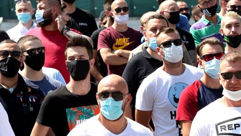
Η χρήση μάσκας είναι υποχρεωτική σε εσωτερικούς χώρους εργασίας και εξωτερικούς χώρους με συγχρωτισμό, σε όλα τα επίπεδα συναγερμού για όλη την χώρα.
Περιορίζεται το ωράριο λειτουργίας της εστίασης και των κέντρων ψυχαγωγίας σε όλα τα επίπεδα συναγερμού, δηλαδή σε όλη την χώρα, σε όλη την επικράτεια. Πιο συγκεκριμένα, οι παραπάνω επιχειρήσεις δεν θα λειτουργούν από τη 1 μετά τα μεσάνυχτα ως τις 5 το πρωί, στις περιοχές που βρίσκονται στο επίπεδο 1. Από τις 12:30 το βράδυ ως τις 5 το πρωί, στις περιοχές που βρίσκονται στο επίπεδο 2. Και από τα μεσάνυχτα έως τις 5 το πρωί στις περιοχές που βρίσκονται στο επίπεδο 3.
Στις συναθροίσεις σε εξωτερικούς και εσωτερικούς χώρους, ορίζεται ανώτατο όριο χωρίς εξαιρέσεις τα 100 άτομα για τις περιοχές στο επίπεδο 1, τα 50 άτομα για τις περιοχές στο επίπεδο 2 και τα 9 άτομα στις περιοχές που βρίσκονται στο επίπεδο 3.
Τίθενται αναλογικοί κανόνες τετραγωνικών και πληρότητας σε συνέδρια, χώρους λατρείας και μουσεία.
Τίθενται αυστηρά όρια πληρότητας σε θέατρα, σινεμά και συναυλίες, που είναι τα εξής: 65% στο επίπεδο 1, 50% στο επίπεδο 2, 30% στο επίπεδο 3.
Τα όρια πληρότητας στην εστίαση καθορίζονται σε 80% για το επίπεδο 1, 65% για το επίπεδο 2 και 50% για το επίπεδο 3.
Προβλέπεται χρήση μάσκας στα γυμναστήρια για το προσωπικό, αλλά και τους αθλούμενους, αναλόγως του επιπέδου συναγερμού.
Σε τι επίπεδο έχει κατανεμηθεί η κάθε περιφερειακή ενότητα
Σύμφωνα με τον Χάρτη Υγειονομικής Ασφάλειας και Προστασίας από τις 74 Περιφερειακές Ενότητες οι 27 ανήκουν στο επίπεδο 1, (σε ετοιμότητα), 25 βρίσκονται στο επίπεδο 2, (σε κατάσταση επιτήρησης), και 22 στο επίπεδο 3, (σε κατάσταση δηλαδή αυξημένης επιτήρησης), ενώ καμία δεν βρίσκεται σε κατάσταση αυξημένου κινδύνου (επίπεδο 4).
Αναλυτικά έχουν κατανεμηθεί ως εξής:
Επίπεδο 1: Άνδρος, Αρκαδία, Άρτα, Δράμα, Έβρος, Ευρυτανία, Ηλεία, Θάσος, Θεσπρωτία, Ιθάκη, Ικαρία, Καβάλα, Κάλυμνος, Κάρπαθος- Κάσος, Κεφαλληνία, Λασίθι, Λευκάδα, Λήμνος, Μεσσηνία, Μήλος, Ρέθυμνο, Σέρρες, Σποράδες, Σύρος, Τήνος, Φωκίδα, Χανιά
Επίπεδο 2: Αιτωλοακαρνανία, Αργολίδα, Βοιωτία, Γρεβενά, Εύβοια, Ημαθία, Θεσσαλονίκη, Κέρκυρα, Κιλκίς , Κορινθία, Κως, Λακωνία, Λάρισα, Μαγνησία, Νάξος, Ξάνθη, Πάρος, Πιερία, Πρέβεζα, Ροδόπη, Ρόδος, Φθιώτιδα, Φλώρινα, Χαλκιδική, Χίος.
Επίπεδο 3: Ανατολική Αττική, Αχαΐα, Βόρειος Τομέας Αθηνών, Δυτική Αττική, Δυτικός Τομέας Αθηνών, Ζάκυνθος, Ηράκλειο, Θήρα, Ιωάννινα, Καρδίτσα, Καστοριά, Κέα- Κύθνος, Κεντρικός Τομέας Αθηνών, Κοζάνη, Λέσβος, Μύκονος, Νήσοι Αττικής, Νότιος Τομέας Αθηνών, Πειραιάς, Πέλλα, Σάμος, Τρίκαλα.
Παράλληλα, στην τελευταία ενημέρωση για την πορεία της πανδημίας στη χώρα ο υφυπουργός Πολιτικής Προστασίας και Διαχείρισης Κρίσεων ξεκαθάρισε ότι «με βάση τα σημερινά δεδομένα βρισκόμαστε μακριά από την ένταξη της Αττικής στο επίπεδο 4, και μένει κάθε μέτρο που εφαρμόζεται να φέρνει κάποια αποτελέσματα. Για την ώρα η καμπύλη στην Αττική παραμένει επίπεδη».
Ο καθορισμός του επιπέδου συναγερμού σε κάθε περιοχή εξαρτάται από την αυξανόμενη ή μειούμενη τάση επιδημιολογικών μεγεθών, όπως ο αριθμός κρουσμάτων ανά 100 χιλιάδες κατοίκους, των δεικτών πληρότητας του συστήματος Υγείας (πχ. χρησιμοποιούμενες απλές κλίνες και κλίνες Μονάδων Εντατικής Θεραπείας) και των ποιοτικών χαρακτηριστικών της επιδημιολογικής κατάστασης, όπως αυτά αποτυπώνονται από τα δεδομένα της ιχνηλάτησης. Η γεωγραφική αναφορά και εφαρμογή των μέτρων πραγματοποιείται σε επίπεδο περιφερειακής ενότητας, εκτός αν προκύψουν έκτακτες περιστάσεις σύμφωνα με τα πρωτόκολλα του υπουργείου Υγείας και της Πολιτικής Προστασίας που να δικαιολογούν εξαιρέσεις σε τοπικό επίπεδο εντός της περιφερειακής ενότητας.
Η ενημέρωση για τα προληπτικά μέτρα σε κάθε περιοχή της χώρας μπορεί να γίνει με τρεις τρόπους: α) με την εισαγωγή ταχυδρομικού κωδικού στο σχετικό πεδίο β) επιλέγοντας την περιφερειακή ενότητα από το οικείο μενού ή γ) κάνοντας κλικ στην περιοχή ενδιαφέροντος πάνω στον χάρτη.
Ο χάρτης, σύμφωνα με το ΑΠΕ, θα επικαιροποιείται ανά 14 ημέρες με βάση τις εισηγήσεις ειδικής επιτροπής λοιμωξιολόγων του υπουργείου Υγείας ή και συχνότερα, όταν αυτό επιβάλλεται από τους υγειονομικούς και επιδημιολογικούς δείκτες. Ο προσδιορισμός των μέτρων και κανόνων υπόκειται σε τροποποιήσεις με βάση νεότερα επιστημονικά και ερευνητικά δεδομένα.
Σημειώνεται ότι η ιστοσελίδα με τον χάρτη υγειονομικής ασφάλειας και προστασίας είναι η https://covid19.gov.gr/
Πηγή:aftodioikisi.gr
Με βάση τον χάρτη υγειονομικής προστασίας και ασφάλειας που παρουσιάστηκε από τον υπουργό Ψηφιακής Διακυβέρνησης, Κυριάκο Πιερρακάκη και τον υφυπουργό Πολιτικής Προστασίας και Διαχείρισης Κρίσεων, Νίκο Χαρδαλιά, 74 περιφερειακές ενότητες της χώρας εντάσσονται πλέον σε επίπεδα υγειονομικής ασφάλειας και προστασίας με αντίστοιχες δέσμες μέτρων που ισχύουν για όλους. Πιο συγκεκριμένα εντάσσονται στα εξής επίπεδα: Επίπεδο 1 – Ετοιμότητας, Επίπεδο 2 – Επιτήρησης, Επίπεδο 3 – Αυξημένης Επιτήρησης και Επίπεδο 4 – Αυξημένου Κινδύνου.
Τι ισχύει από σήμερα σε όλη την Ελλάδα
Η χρήση μάσκας είναι υποχρεωτική σε εσωτερικούς χώρους εργασίας και εξωτερικούς χώρους με συγχρωτισμό, σε όλα τα επίπεδα συναγερμού για όλη την χώρα.
Περιορίζεται το ωράριο λειτουργίας της εστίασης και των κέντρων ψυχαγωγίας σε όλα τα επίπεδα συναγερμού, δηλαδή σε όλη την χώρα, σε όλη την επικράτεια. Πιο συγκεκριμένα, οι παραπάνω επιχειρήσεις δεν θα λειτουργούν από τη 1 μετά τα μεσάνυχτα ως τις 5 το πρωί, στις περιοχές που βρίσκονται στο επίπεδο 1. Από τις 12:30 το βράδυ ως τις 5 το πρωί, στις περιοχές που βρίσκονται στο επίπεδο 2. Και από τα μεσάνυχτα έως τις 5 το πρωί στις περιοχές που βρίσκονται στο επίπεδο 3.
Στις συναθροίσεις σε εξωτερικούς και εσωτερικούς χώρους, ορίζεται ανώτατο όριο χωρίς εξαιρέσεις τα 100 άτομα για τις περιοχές στο επίπεδο 1, τα 50 άτομα για τις περιοχές στο επίπεδο 2 και τα 9 άτομα στις περιοχές που βρίσκονται στο επίπεδο 3.
Τίθενται αναλογικοί κανόνες τετραγωνικών και πληρότητας σε συνέδρια, χώρους λατρείας και μουσεία.
Τίθενται αυστηρά όρια πληρότητας σε θέατρα, σινεμά και συναυλίες, που είναι τα εξής: 65% στο επίπεδο 1, 50% στο επίπεδο 2, 30% στο επίπεδο 3.
Τα όρια πληρότητας στην εστίαση καθορίζονται σε 80% για το επίπεδο 1, 65% για το επίπεδο 2 και 50% για το επίπεδο 3.
Προβλέπεται χρήση μάσκας στα γυμναστήρια για το προσωπικό, αλλά και τους αθλούμενους, αναλόγως του επιπέδου συναγερμού.
Σε τι επίπεδο έχει κατανεμηθεί η κάθε περιφερειακή ενότητα
Σύμφωνα με τον Χάρτη Υγειονομικής Ασφάλειας και Προστασίας από τις 74 Περιφερειακές Ενότητες οι 27 ανήκουν στο επίπεδο 1, (σε ετοιμότητα), 25 βρίσκονται στο επίπεδο 2, (σε κατάσταση επιτήρησης), και 22 στο επίπεδο 3, (σε κατάσταση δηλαδή αυξημένης επιτήρησης), ενώ καμία δεν βρίσκεται σε κατάσταση αυξημένου κινδύνου (επίπεδο 4).
Αναλυτικά έχουν κατανεμηθεί ως εξής:
Επίπεδο 1: Άνδρος, Αρκαδία, Άρτα, Δράμα, Έβρος, Ευρυτανία, Ηλεία, Θάσος, Θεσπρωτία, Ιθάκη, Ικαρία, Καβάλα, Κάλυμνος, Κάρπαθος- Κάσος, Κεφαλληνία, Λασίθι, Λευκάδα, Λήμνος, Μεσσηνία, Μήλος, Ρέθυμνο, Σέρρες, Σποράδες, Σύρος, Τήνος, Φωκίδα, Χανιά
Επίπεδο 2: Αιτωλοακαρνανία, Αργολίδα, Βοιωτία, Γρεβενά, Εύβοια, Ημαθία, Θεσσαλονίκη, Κέρκυρα, Κιλκίς , Κορινθία, Κως, Λακωνία, Λάρισα, Μαγνησία, Νάξος, Ξάνθη, Πάρος, Πιερία, Πρέβεζα, Ροδόπη, Ρόδος, Φθιώτιδα, Φλώρινα, Χαλκιδική, Χίος.
Επίπεδο 3: Ανατολική Αττική, Αχαΐα, Βόρειος Τομέας Αθηνών, Δυτική Αττική, Δυτικός Τομέας Αθηνών, Ζάκυνθος, Ηράκλειο, Θήρα, Ιωάννινα, Καρδίτσα, Καστοριά, Κέα- Κύθνος, Κεντρικός Τομέας Αθηνών, Κοζάνη, Λέσβος, Μύκονος, Νήσοι Αττικής, Νότιος Τομέας Αθηνών, Πειραιάς, Πέλλα, Σάμος, Τρίκαλα.
Παράλληλα, στην τελευταία ενημέρωση για την πορεία της πανδημίας στη χώρα ο υφυπουργός Πολιτικής Προστασίας και Διαχείρισης Κρίσεων ξεκαθάρισε ότι «με βάση τα σημερινά δεδομένα βρισκόμαστε μακριά από την ένταξη της Αττικής στο επίπεδο 4, και μένει κάθε μέτρο που εφαρμόζεται να φέρνει κάποια αποτελέσματα. Για την ώρα η καμπύλη στην Αττική παραμένει επίπεδη».
Ο καθορισμός του επιπέδου συναγερμού σε κάθε περιοχή εξαρτάται από την αυξανόμενη ή μειούμενη τάση επιδημιολογικών μεγεθών, όπως ο αριθμός κρουσμάτων ανά 100 χιλιάδες κατοίκους, των δεικτών πληρότητας του συστήματος Υγείας (πχ. χρησιμοποιούμενες απλές κλίνες και κλίνες Μονάδων Εντατικής Θεραπείας) και των ποιοτικών χαρακτηριστικών της επιδημιολογικής κατάστασης, όπως αυτά αποτυπώνονται από τα δεδομένα της ιχνηλάτησης. Η γεωγραφική αναφορά και εφαρμογή των μέτρων πραγματοποιείται σε επίπεδο περιφερειακής ενότητας, εκτός αν προκύψουν έκτακτες περιστάσεις σύμφωνα με τα πρωτόκολλα του υπουργείου Υγείας και της Πολιτικής Προστασίας που να δικαιολογούν εξαιρέσεις σε τοπικό επίπεδο εντός της περιφερειακής ενότητας.
Η ενημέρωση για τα προληπτικά μέτρα σε κάθε περιοχή της χώρας μπορεί να γίνει με τρεις τρόπους: α) με την εισαγωγή ταχυδρομικού κωδικού στο σχετικό πεδίο β) επιλέγοντας την περιφερειακή ενότητα από το οικείο μενού ή γ) κάνοντας κλικ στην περιοχή ενδιαφέροντος πάνω στον χάρτη.
Ο χάρτης, σύμφωνα με το ΑΠΕ, θα επικαιροποιείται ανά 14 ημέρες με βάση τις εισηγήσεις ειδικής επιτροπής λοιμωξιολόγων του υπουργείου Υγείας ή και συχνότερα, όταν αυτό επιβάλλεται από τους υγειονομικούς και επιδημιολογικούς δείκτες. Ο προσδιορισμός των μέτρων και κανόνων υπόκειται σε τροποποιήσεις με βάση νεότερα επιστημονικά και ερευνητικά δεδομένα.
Σημειώνεται ότι η ιστοσελίδα με τον χάρτη υγειονομικής ασφάλειας και προστασίας είναι η https://covid19.gov.gr/
Πηγή:aftodioikisi.gr


