


Πρόσκαιρη αλλά σημαντική επιδείνωση αναμένεται να παρουσιάσει ο καιρός σήμερα στο Ιόνιο και στα δυτικά ηπειρωτικά, ενώ κατά τη διάρκεια της Τρίτης η κακοκαιρία θα επεκταθεί στο σύνολο της χώρας, σύμφωνα με τα προγνωστικά στοιχεία του Εθνικού Αστεροσκοπείου Αθηνών/meteo.gr.
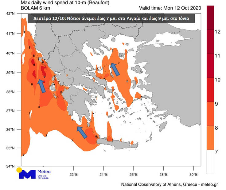
Κύρια χαρακτηριστικά της μεταβολής του καιρού θα είναι οι ισχυρές βροχές και καταιγίδες, οι οποίες κατά τόπους θα συνοδεύονται από αυξημένη ηλεκτρική δραστηριότητα και χαλαζοπτώσεις, καθώς επίσης οι πολύ ενισχυμένοι νοτιάδες, οι εντάσεις των οποίων στα πελάγη θα φτάσουν πρόσκαιρα τα εννέα μποφόρ.
Σήμερα, βροχές ή καταιγίδες τοπικού χαρακτήρα θα εκδηλωθούν μετά το μεσημέρι στα δυτικά και βόρεια. Ωστόσο, από αργά το βράδυ της Δευτέρας έως και τις πρώτες ώρες μετά τα μεσάνυχτα, η Δυτική Ελλάδα θα επηρεαστεί από κατά τόπους πολύ έντονα φαινόμενα, τα οποία θα έχουν τη μορφή μετώπου. Πολύ αυξημένη είναι η πιθανότητα χαλαζοπτώσεων.
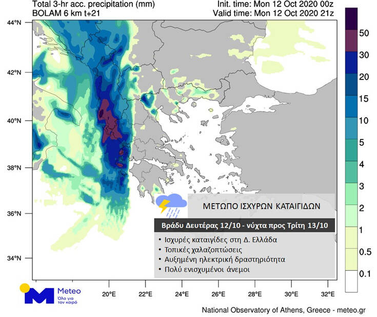
Κατά τη διάρκεια της διέλευσης του μετώπου των καταιγίδων από το Ιόνιο, οι νότιοι άνεμοι θα παρουσιάσουν πρόσκαιρη ενίσχυση στα 8-9 μποφόρ.
Τη νύχτα προς Τρίτη τα φαινόμενα θα επεκταθούν ανατολικότερα, επηρεάζοντας τα ηπειρωτικά τμήματα της χώρας, ενώ κατά τη διάρκεια της Τρίτης τα ισχυρότερα φαινόμενα θα εντοπίζονται στην Κεντρική και Ανατολική Μακεδονία, τη Θράκη και τα νησιά του Βόρειου και Ανατολικού Αιγαίου. Παράλληλα, οι βροχές και οι καταιγίδες στη Δυτική Ελλάδα θα επιμείνουν.
Τα ξημερώματα και τις πρωινές ώρες της Τρίτης, βροχές και καταιγίδες θα εκδηλωθούν στην Αττική, με τα φαινόμενα ενδεχομένως να είναι πρόσκαιρα έντονα.
Πηγή:Newsbeast.gr


